Fantastic GPS Logger, a Field Report for BT-1000P
To add to the ever increasing arsenal of gadgets to never leave at home, comes the BT-1000P GPS Logger.
Having recently purchased the unit, especially for the purpose tagging all the photos for an upcoming trip, I flew away extremely happy, witnessing the outstanding performance of this little device. You can see a screenshot of Google Earth displaying the track below; its the takeoff from Sydney towards Tokyo.
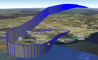
What sets this unit apart from other loggers and GPS units on the market, is its ability to not only acquire a signal within the boundaries of an airplanes fuselage, but keep that sync as the airplane is banking. This latter achievement is the result of the -158dBm sensitivity rating of the unit.
Geotagging
In order to couple the data off the unit with your images, first of all you must make sure that the date+time is the same on both the unit, and your camera. Then based on the time of each point recorded and the time a photo was taken, the closest data point becomes the location of where the photo was taken.
There’s nothing you can do about the GPS, since its sync’ed with the satellites and stored in UTC. What is important though is to adjust the cameras time to the Time Zone of your location, this will save you much heartache later on when you have to adjust the times.
For my needs, I thought I’d try out HoudahGeo, and GPSPhotoLinker. I very quickly dismissed HoudahGeo, because I was unable to try it ‘properly’. By which I mean use it unrestricted for a period of my journey. I don’t believe its possible to evaluate certain software unless you can actually try your complete workflow with the software, and see if it fits, HoudahGeo unfortunately provides you with a handicapped version.
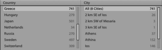
In comes GPSPhotoLinker, which is actually a free app, and gets the job done surprisingly well. What you’ll notice is that once you combine your photos with the exported data from the GPS, it will actually look up the City and Suburb data as well and embed that into the EXIF along with the GPS location. This is extremely useful for my Lightroom catalog where I can pick things based on the City as looked up by GPSPhotoLinker - brilliant! This is extremely helpful when you’re island-hopping, as is inevitable in Greece, or are merely in a new place.
As it stands, I think its a wonderful little unit that has served its purpose extremely well. I would highly recommend it, and will not be leaving the house without. It now lives at the top of my camera bag.